电感耦合等离子体质谱法研究乌梁素海上覆水-沉积物-植物-鱼体系中重金属的分布和评价
[梁飘飘1 , 幸韵欣1 , 魏春丽1 , 李媛媛1 , 刘一鸣1 , 胡钰1 , 刘颖1, 2, *  ]
]
]
|
|


重金属污染已经成为全球性问题, 由于其毒性、 持久性和在食物链中的生物富集特点, 对水生环境构成严重威胁。 本研究选取乌梁素海为研究区域, 采用电感耦合等离子体质谱法(
Heavy metal (HM) contamination has become a widespread global problem and posed threat to the aquatic environment due to their toxicity, persistence and bioenrichment in the food chain. In this study, overlying water, sediment, Potamogeton pectinatus L. ( P. pectinatus), Phragmites australis ( P. australis), and four types of fish in Wuliangsuhai Lake, China, were analyzed for HMs. The Inductively Coupled Plasma Mass Spectrometry (ICP-MS) was used to determine the contents of HMs in collected samples in order to investigate their spatial distribution, enrichment characteristic, risk assessment and the possible sources. The results showed that: (1) The mean levels of Cr, Ni, Cu, Mn, Pb and Zn mainly followed an order of sediment> P. pectinatus (submerged plants)> P. australis (emergent plants)>fishes>overlying water, but for As, the concentration in overlying water was higher than that in P. australis and fishes. The content of Cd, in P. australis was almost 50 times higher than that in normal plants and in fish was 3.3 times higher than the permissible threshold standards in China, leading to potential hazards to fish and human health via food chain bioaccumulation. (2) In sediment As and Cd experienced moderately severe enrichment. For P. pectinatus, the higher bioconcentration factor (BCF) and the lower biota-sediment accumulation factor (BASF) indicated that this species was more likely to accumulate HMs from overlying water and could remove HMs from Wuliangsuhai Lake as a hyperaccumulator. (3) In sediment, the
Heavy metal (HM) contamination of lake systems has been considered as a long recognized and persistent environmental problem and posed a large threat to environmental quality and human health[1]. Sediments act not only as a major sink of HMs in aquatic ecosystems but also as a secondary pollution source impacting the water quality when the physical and chemical properties of the water change[2]. Anthropogenic HMs in sediments have been considered to have higher mobility, bioavailability and adverse effects compared with metals of natural origin[3]. Aquatic plants are considered as natural sinks for metals because they can adsorb and accumulate large amounts of metals from sediments and water[4]. Therefore, there has been increasing interest in the study of metal-accumulating plants as phytoremediators[5], which were harvested and disposed to prevent recycling of accumulated metals when the plants decomposed[4]. Fish are often used as the most suitable bioindicator to investigate ecological environments and potential health risks via dietary exposure since they occupy a high trophic level[1].
Wuliangsuhai Lake is located at the end of the Hetao region near the plain in northern Inner Mongolia, China, and is the largest freshwater lake in the Yellow River basin and a typical macrophytic lake in a cold and arid region. In recent years, Wuliangsuhai Lake has suffered from multiple types of pollution from farmland irrigation, industrial sewage, papermaking facilities, metal smelting activities, small fertilizer plants and municipal wastewater, etc., resulting in frequent pollution incidents and affecting the Yellow River water quality[6]. In particular, with the superfluous growth of P. pectinatus and P. australis, Wuliangsuhai Lake has evolved into a macrophytic lake suffering from severe eutrophication. To date in Wuliangsuhai Lake, researches have primarily focused on analyzing eutrophication[7] rather than the heavy metal transmission in the overlying water-sediment-plant-fish system, which is essential to understand HM geochemical cycling. Based on the discussion above, the goals of our study are (1) to investigate the distribution of HMs in the overlying water, sediments, plants (P. pectinatus and P. australis) and fishes (crucian, carp, catfish and mullet) in Wuliangsuhai Lake; (2) to determine the potential ecological risk of HMs; and (3) to identify the contributing sources of HMs in sediment samples with multivariate statistical methods.
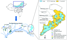
In October 2016, samples were collected from 19 different sites in Wuliangsuhai Lake: S1-S17, A and Z from the overlying water (the inlet and outlet of the lake, respectively) The data sets of Chinese Map and Wuliangsuhai Lake are provided by Data Center for Resources and Environmental Sciences, Chinese Academy of Sciences (http://www.resdc.cn); the date set of Hetao irrigation system was cited from Liu et al.[6] and modified by Photoshop (Fig.1). Seventeen sediments (S1— S17) were also gathered by a gravity corer. Ten P.pectinatus (
 | Fig.1 Map of Wuliangsuhai Lake and the sampling locations |
The collected plant, sediment and fish samples were digested with HNO3-H2O2 (guaranteed reagent, GR), HNO3-H2O2-HF (GR) and HNO3 (
| Table 1 Operating parameters of ICP-MS |
The enrichment factor (EF), bioconcentration factor (BCF) and the biota-sediment accumulation factor (BASF) were used to determine the enrichment characteristics of the HMs, which were referenced from Ref.[8] and [9]. In sediment, the potential ecological risk index (RI) was used to evaluate the potential ecological risk of metal contaminants. The RI grading standard was modified by using the weighted average method[10]. Data analysis was performed using the SPSS 22.0 software package for Windows. Principal component analysis (PCA) was used to determine the relationship among HMs in sediments and their possible sources. The spatial distribution patterns of the RI value at each site were obtained by using geostatistical analysis in geographic information system (GIS) software (Arc GIS, version 10.2)
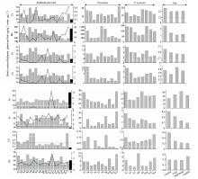
In this study, the mean levels of Cr, Ni, Cu, Mn, Pb and Zn mainly followed an order of sediment> P. pectinatus (submerged plants)> P. australis (emergent plants)> fishes> overlying water (Fig.2), but we found that the concentration distribution of As in overlying water was higher than that in P. australis and fishes possibly because As and P are cognate elements with similar physical and chemical properties and that P from agricultural runoff competed with As for adsorption points on the oxide surfaces of solid-liquid interfaces, causing As to desorb and ultimately drain into the channel[6]. Additionally, it was interesting that the order of the Cd content— P. australis> fishes> P. pectinatus> sediment (Cd was not detected in the overlying water)— was different from that of the other elements, and the content of Cd in P. australis was almost 50 times higher than that in normal plants (0.05 to 0.2 mg kg-1 [5]); in four types of fish, Cd was 3.3 times higher than the permissible threshold standards in China, leading to inhibition of plant growth, excessive accumulation of Cd in plants, and potential hazards to fish and human health via food chain bioaccumulation[11].
 | Fig.2 HM contents in overlying water-sediment-plant-fish in Wuliangsuhai Lake |
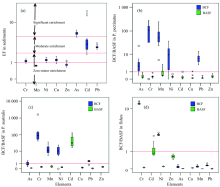
Water contents (μ g· L-1) were shown in a line graph; contents (mg· kg-1) in sediment, P. pectinatus, P. australis and fish were shown in a bar graph; and their respective Chinese national quality values (solid lines) are shown for the collected samples According to the EF grading criteria, As and Cd experienced moderately severe enrichment and might originate from industrial and agricultural nonpoint source pollution [Fig.3(a)]. Based on the BCF and BASF, we found that in P. pectinatus and P. australis [Fig.3(b), (c)], the BCF of all metals was greater than 1, but the BASFs were lower than 1, except Cd, demonstrating that P. pectinatus was more likely to accumulate HMs from overlying water because its leaf surface had a special porous structure that increased the area available for adsorption and promotes the adsorption of metal ions[11]. Finally, in the crucian, carp, catfish and mullet, the BCFs and BASFs were almost less than 1 (except for the BCFs of Cr and Ni and the BASF of Cd) [Fig.3(d)]. These results indicated that these fish species tended to restrict their uptake of metals from water and sediments to guarantee their growth; however, the bioaccumulation level of metals in fish might not cause any adverse effects in the fish itself but might pose a hazard to their predators, such as piscivorous birds, mammals and human[1].
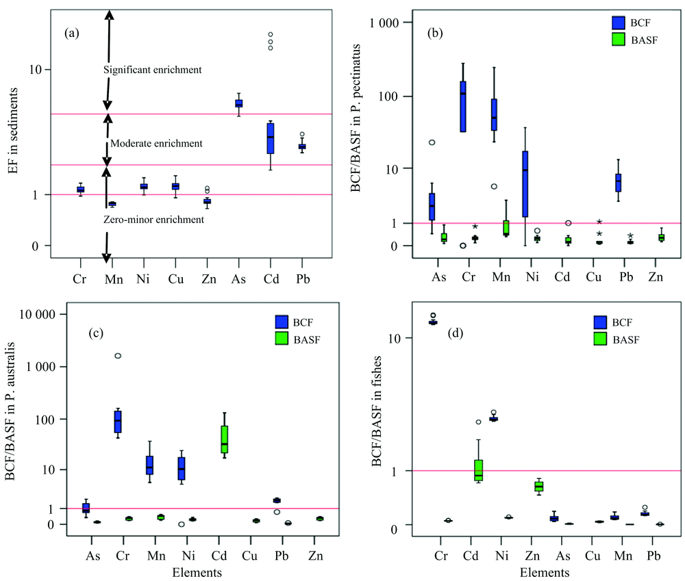 | Fig.3 Box-Whisker plots of the EFs in surface sediments and BCF/BASF in plants and fishes (a): EFs in sediment; (b): BCFs/BASFs in P. pectinatus; (c): BCFs/BASFs in P. australis; (d): BCFs/BASFs in fish. The box shows the 25th and 75th percentiles, and the whiskers represent the smallest and the largest values. The red line represents the values of 2 and 5, the dotted line shows EF=1 in Fig.3(a), and the red lines stand for a value of 1 in Fig.3(b)— (d) |
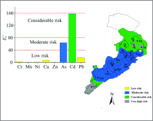
The contents of As, Cd and Pb in sediments were 6.4, 5.8 and 3.1 times higher than the soil background values and exceeded the standard limits of 100%, 18% and 18% at all sites (Fig.2), respectively, demonstrating that they could affect lake sediment quality.
Based on the ecological risk grades of a single metal, the
 | Fig.4 Evaluation on potential ecological risk of HM pollution in sediments of the Wuliangsuhai Lake |
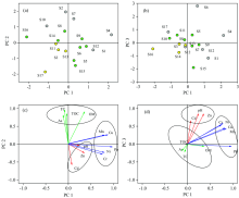
The results of principal component analysis (PCA) revealed that there were three principal components (PCs) for the sediment samples, with an explanation of 86.33% (PC1 30.3%; PC2 27.17%; PC3 25.94%) of the total variance (Fig.5). In Fig.5(c) and (d), we found that sites S4, S6, S7 and S17 apparently had a high correlation with PC1, PC2 and PC3, indicating that the HM contents at these sites were high, which was in agreement with the RI assessment showing a very high risk at S6 and S17. Fig.5(a) and (b) showed that PC1 had high loadings for Pb (r=0.97), Cu (r=0.818), Mn (r=0.781), Ni (r=0.76) and Cr (r=0.743), which are abundant elements in nature. Clay minerals were derived from weathered rock basins and reach lake water by leaching in surface runoff, finally accumulating in sediments[6]. The sediments in Wuliangsuhai Lake were mainly formed from clay; therefore, Cu, Fe, Mn and Cr were the main components of the sediments and weathered products. The ecological risks posed by Cr, Cu and Pb were all low in this study, indicating that the impacts from human activities on these elements were small. Therefore, PC1 was mainly associated with natural weathering and deposition.
 | Fig.5 Loading and score diagram from the PCA of HMs and other factors in Wuliangsuhai Lake (a), (b): The arrows with different colors represent the variables belonging to diverse components; (c), (d): yellow, green and gray dots represent relatively lower, intermediate and relatively higher levels of scores for the sampling sites, respectively |
PC2 had high positive loadings for Zn (r=0.847), Cd (r=0.625), and pH (r=0.876), which were deemed to have primarily anthropogenic sources. We found that around Wuliangsuhai Lake, there were dozens of chemical fertilizers and mineral processing enterprises, such as the Huafeng zinc oxide operation, the Tanyaokou pyrite operation, mining plants, the Bameng Ring Farm mine, the Urals fertilizer plants, the chemical plants in Wuyuan and the fertilizer plants in Linhe (Fig.1). These operations were located in drainage channels that empty into the lake, and industrial wastewater and municipal sewage were the main potential sources of pollution by HMs, such as Cd and Zn[12]. Therefore, PC2 in sediments was mainly an industrial sewage and waste source. In this study, the weakly alkaline conditions (
PC3 had high positive loadings for As (r=0.84), organic matter (OM) (r=0.867), and TOC (r=0.811). The heavy use and low efficiency of chemical fertilizers have resulted in large amounts of phosphate residues in agricultural runoff. As mentioned above, phosphorus competes with As for adsorption to sediments; thus, phosphate in agricultural runoff will compete for the adsorption sites on oxide surfaces, causing As to desorb from oxide surfaces and ultimately drain into the channel. Huang et al. (2008)[14] showed that the average content of TP in the Hetao Irrigation District was 1.99 mg· kg-1, exceeding Grade V (0.2 mg· kg-1 in lakes) of the Surface Water Quality guidelines in China (GB 3838— 2002). It was likely that an increasing amount of As in the water and soil would be released into the channel and the lake, that is, the As pollution was partly caused by agricultural nonpoint source pollution and agricultural runoff.
Overall, PC1 was the result of natural weathering and deposition, and PC2 was primarily due to anthropogenic sources, and PC3 was mostly a result of agricultural nonpoint sources.
This study remedies the insufficient amount of data on heavy metals in the overlying water-sediment-plant-fish systems. In the present study, the contents of heavy metals in sediments were higher than those in P. pectinatus, P. australis, fishes and overlying water. For P. pectinatus, its higher BCF and lower BASF indicated that this species was more likely to accumulate heavy metals from water and could remove HMs from Wuliangsuhai Lake as a hyperaccumulator. In sediments, the
The authors have declared that no competing interests exist.
| [1] |
|
| [2] |
|
| [3] |
|
| [4] |
|
| [5] |
|
| [6] |
|
| [7] |
|
| [8] |
|
| [9] |
|
| [10] |
|
| [11] |
|
| [12] |
|
| [13] |
|
| [14] |
|